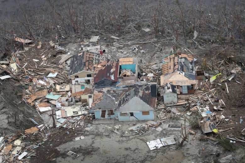
Hurricane Dorian left stretches of the Bahamas looking as if they had been carpet bombed and was regaining strength as it crawled up the U.S. Atlantic coast, possibly making landfall later on Thursday in South Carolina.
The United Nations said 70,000 people in the Bahamas needed immediate humanitarian relief after the most damaging storm ever to hit the island nation.
Aerial video of the worst-hit Abaco Islands in northern Bahamas showed widespread devastation, with the harbour, shops, workplaces, a hospital, and airport landing strips damaged or blown to pieces, all of which was frustrating rescue efforts.
One of the most powerful Caribbean storms on record, the Category 5 hurricane killed at least 20 people in the Bahamas. Authorities expected that number to rise, Prime Minister Hubert Minnis told a news conference on Wednesday, as retreating floodwaters were revealing the scope of destruction.
It’s believed the storm destroyed or severely damaging 45 per cent of the homes in Abaco and Grand Bahama.
With many telephones down, residents posted lists of missing loved ones on social media. One Facebook post by media outlet Our News Bahamas had 2,000 comments, mainly listing lost family.
The powerful storm made landfall on Sunday in Elbow Cay, Bahamas and pounded the islands for more than two days.
Dorian killed one person in Puerto Rico before making landfall Sunday in Elbow Cay, Bahamas with torrential rains and storm surges measuring 3.7 to 5.5 metres.
An international relief effort was underway for the Bahamas, with a British Royal Navy vessel providing assistance and Jamaica sending a 150-member military contingent to help secure Abaco and Grand Bahama, officials said.

Volunteers also ferried supplies to the islands in a flotilla of small boats.
“Let us give of our best in this moment of historic tragedy,” Minnis said.
Tourists still encouraged to visit
He also encouraged international tourists to visit the Bahamas, which relies heavily on its hospitality industry.
As many as 13,000 homes in the Bahamas may have been destroyed or severely damaged, the International Federation of Red Cross and Red Crescent Societies said.
In the United States, South Carolina was preparing for a record storm surge, potentially reaching a height of two metres at the popular vacation destination of Myrtle Beach, the U.S. National Hurricane Center (NHC) said in an advisory.

About 300 millimetres of rain will drop on flood-prone Charleston, S.C. and many parts of the coasts of the Carolinas on Thursday and Friday, said Bob Oravec, a forecaster with the National Weather Service’s Weather Prediction Center in College Park, Md.
“It’s pretty substantial. It’s already raining heavy in Charleston and up and down the coast,” he said early Thursday.
Media reported flooding in historic downtown Charleston from the now-Category 3 hurricane before sunup early Thursday, and more than 160,000 homes and businesses were without power along the South Carolina and Georgia coastal areas, according to the tracking site poweroutage.us.
At 5 a.m. ET on Thursday, Dorian was about 130 kilometres south-southeast of Charleston, the NHC said.
The NHC has issued a storm surge warning that covered the parts of the coasts of Georgia, South Carolina and North Carolina stretching from the Savannah River and extending to southern Virginia.