Winter returns: Snowfall warning in effect for Edmonton, other areas
A powerful winter storm is expected to hammer the province Tuesday with heavy snow — and put an end to a recent spat of above average temperatures.
A snowfall warning first issued Monday remains in effect for Edmonton and surrounding communities as a low pressure system descends on the area.
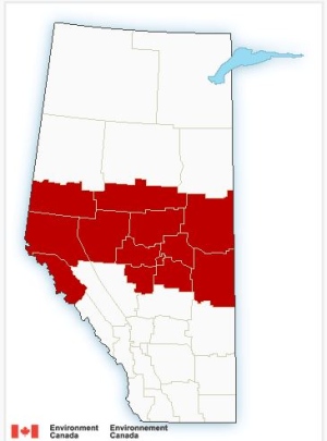
(Environment Canada)
Between 10 and 15 centimetres of snow is expected to fall in a 12-hour span Tuesday as a winter storm begins to wallop a band of communities across the province.
A large swath of northern Alberta remains under advisory, as the system moves across Alberta, from B.C. to Saskatchewan. The storm is expected to spread eastward Tuesday morning, tapering off by late afternoon.
A warning from Environment Canada stretches from Hinton and Grande Prairie in the west, across to the Cold Lake region in the east.
Environment Canada said the highest snowfall will occur north of the Yellowhead Highway, and travellers should expect gusting winds and reduced visibility, especially in the east central parts of the province.
Rapidly accumulating snow could make travel on highways and city roads difficult, and there may be a “significant impact” on rush-hour traffic in urban areas, Environment Canada said.
As the low pressure system exits the province, an awaiting high pressure ridge will move in, allowing frigid Arctic air to flow into Alberta.
The daytime highs near zero on Monday will drop nearly 20 degrees by Tuesday evening.
“These cold temperatures will stubbornly persist into the weekend,” said Environment Canada.